San Antonio Crime Rate 2026: The Real Safety Overview
San Antonio Crime Rate 2026: The Real Safety Overview
San Antonio's 2025 crime trends show progress but reveal ongoing challenges. Key takeaways:
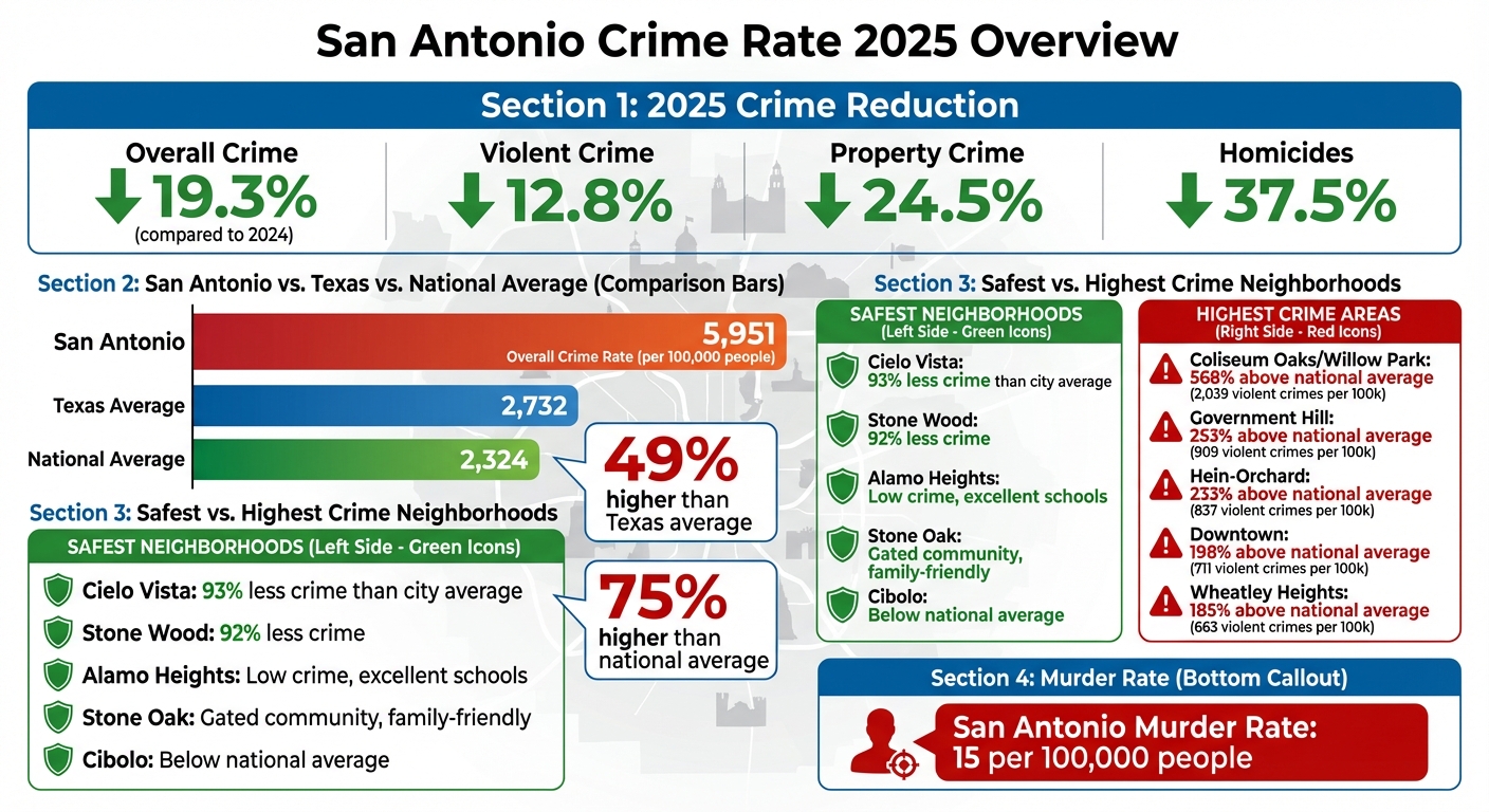
- Crime Down: Overall crime dropped 19.3% in early 2025 compared to 2024, with violent crime down 12.8% and property crime reduced by 24.5%. Homicides also fell by 37.5%.
- Citywide Crime Still High: Despite improvements, San Antonio's crime rate remains 49% higher than the Texas average and 75% above the national average.
- Neighborhood Disparities: Safer areas like Cielo Vista and Stone Oak report significantly lower crime, while neighborhoods like Coliseum Oaks and Wheatley Heights face much higher rates.
- Economic Impact: Crime hotspots often correlate with poverty and unemployment.
For personalized safety insights, tools like AdensZip offer detailed, ZIP code-specific crime data to help residents and investors make informed decisions.
San Antonio Crime Statistics 2025: Key Trends and Neighborhood Comparisons
San Antonio Crime Statistics for 2025
2025 Crime Numbers Breakdown
The first half of 2025 shows encouraging progress in public safety. Crime offenses overall have dropped by 19.3% compared to the same period in 2024. Violent crimes, including assaults and sex offenses, have continued their steady decline. When it comes to property crimes, early 2025 brought noticeable reductions in motor vehicle thefts and burglaries, reversing the increases seen in 2023. That said, motor vehicle theft rates are still higher than pre-pandemic levels, highlighting room for further improvement. These shifts provide valuable insight into long-term safety trends.
10-Year Crime Trends
Looking back over the past decade, San Antonio's crime patterns have undergone significant changes. Violent crime has been on a consistent decline since 2023, thanks in part to focused policing strategies. Property crimes, which spiked in 2023, saw reductions in 2024 and continued to decrease in early 2025. The San Antonio Police Department attributes these positive changes to initiatives like the "hot spot" strategy and the Violent Crime Reduction Plan, which allocate resources to areas with historically higher crime rates to prevent issues from escalating. These targeted efforts appear to be making a measurable difference in the community.
San Antonio police releases 2024 crime statistics during Tuesday city council committee meeting
Safety by Neighborhood
Neighborhood-specific safety data highlights the stark contrasts within San Antonio, showcasing how crime rates and policing strategies vary dramatically across different areas of the city.
Lowest Crime Neighborhoods
San Antonio’s safest neighborhoods often share common features: upscale amenities, high-performing schools, and strong community involvement. Recent crime reports reveal just how much safer these areas are compared to the city average. For instance, Cielo Vista reports 93% less crime, while Stone Wood follows closely at 92% less. The Fountains at Deerfield and Cadillac Drive each see 89% less crime, and Inwood Homeowners records an 86% reduction.
Several neighborhoods stand out for their safety and appeal. Alamo Heights, particularly its northeastern section, combines excellent schools with proximity to downtown, maintaining crime rates far below those in central areas. Stone Oak, a gated, master-planned community in the north, draws families seeking top-tier schools and a peaceful suburban vibe. The Dominion, known for its exclusivity, offers luxury homes, a premier golf course, and a secure, gated environment.
Further northeast, Cibolo boasts crime rates well below both San Antonio’s and the national averages. This suburban area offers excellent schools, diverse dining, and abundant parks, making it a top choice for families. Similarly, Timberwood Park, spanning over 2,200 acres, features custom homes with scenic hilltop views, along with amenities like swimming pools and a large park.
Other safe neighborhoods include Shavano Park, a small, affluent area just outside San Antonio, and Terrell Hills, known for its quiet, tree-lined streets and beautiful homes near downtown. Many of these areas benefit from features like gated access, active neighborhood watch programs, and higher property values, which often correlate with lower crime rates.
However, not all parts of San Antonio enjoy such safety. Some areas face significantly higher crime rates.
Higher Crime Areas
On the flip side, certain neighborhoods in San Antonio experience concentrated crime, particularly on the city’s east side. According to recent data, Coliseum Oaks/Willow Park, near the AT&T Center, has a violent crime rate 568% above the national average, with 2,039 violent crimes and 7,171 property crimes per 100,000 residents. This area struggles with low median incomes, high child poverty rates, and a prevalence of single-parent households. The presence of event venues also contributes to theft and late-night disturbances.
Other neighborhoods with elevated crime rates include Hein-Orchard, which reports 837 violent crimes per 100,000 residents (233% above the national average), and Wheatley Heights, with 663 violent crimes per 100,000 residents (185% above the national average). Wheatley Heights faces additional challenges like gang activity, territorial disputes, and aging infrastructure, all of which hinder safety improvements.
Downtown San Antonio, with its dense population, vibrant nightlife, and high tourist traffic, sees a crime rate 198% above the national average, including 711 violent crimes per 100,000 residents. Nearby, Tobin Hill reports 541 violent crimes per 100,000 residents, with its walkable streets and concentration of bars and restaurants contributing to property theft and car break-ins.
Government Hill, just east of the Pearl, has the highest violent crime rate in the city - 253% above the national average, with 909 violent crimes per 100,000 residents. Limited investment and proximity to other high-crime areas exacerbate the challenges here. Similarly, Los Jardines, plagued by drug trafficking and gang activity, reports violent crime rates 195% above the national average, with its location near major roads further increasing theft risks.
Economic struggles play a major role in shaping these patterns. Areas like Harvard Place/Eastlawn and East Terrell Hills face high poverty and unemployment, leaving residents more vulnerable to property crimes. Likewise, Rainbow Hills and Pipers Meadow contend with elevated property crime rates, driven by economic hardship and their location near busy roads that attract transient activity.
San Antonio vs. Texas and National Crime Rates
Crime Rate Comparison Data
Looking at statewide and national crime data provides a broader perspective on San Antonio's safety challenges. The city reports an overall crime rate of 5,951 crimes per 100,000 people. This figure is 49% higher than the Texas average of 2,732 per 100,000 people and 75% higher than the national average of 2,324 per 100,000 people. These numbers paint a clear picture of San Antonio's elevated crime levels compared to both state and national benchmarks.
When it comes to violent crime, the murder rate in San Antonio is 15 per 100,000. Property crimes, particularly motor vehicle theft, significantly contribute to the city's high overall crime rate.
What the Numbers Show
These comparisons highlight both progress and ongoing challenges for San Antonio. While neighborhood-level data reveals disparities within the city, the broader statistics emphasize the uphill battle against crime across the region. On the positive side, San Antonio has seen notable declines in homicides and violent crimes since the pandemic-era spike, with rates by mid-2025 falling below pre-pandemic levels. This shift marks a promising reversal of troubling trends.
However, the city still falls short of state and national safety standards in most crime categories. The violent crime rate remains significantly higher than both the Texas and U.S. averages. Property crime, which accounts for the bulk of San Antonio's total crime rate, remains a pressing concern for law enforcement and city leaders. Addressing these issues will require sustained focus and strategic efforts to create safer communities.
sbb-itb-6d427fc
What Drives Crime in San Antonio
Economic Factors and Employment
Economic challenges and limited access to social services play a significant role in driving crime in San Antonio. While specific data for 2025 isn't available, experts widely agree that financial instability and a lack of community resources create conditions where crime is more likely to occur.
The San Antonio Police Department (SAPD) focuses on prevention by addressing these root causes of violence. Their efforts aim to allocate resources effectively to areas where they can make the most impact. Alongside addressing economic challenges, strategic policing efforts also work to tackle these underlying issues.
Policing and Safety Programs
San Antonio has introduced several initiatives aimed at reducing crime through smarter, data-driven policing. One notable effort is the Violent Crime Reduction Plan, developed in partnership with the University of Texas at San Antonio (UTSA). This plan employs strategies like "hot spot" policing, place-based approaches, and focused deterrence to address areas with higher crime rates. Additionally, specialized task forces have been created to target property crimes.
In 2023, the city expanded its 911 dispatch program to include paramedics and mental health professionals for certain calls, providing a more comprehensive response to emergencies. SAPD's next phase of "hot spot" policing goes beyond enforcement, addressing neighborhood issues such as code violations and inadequate lighting - factors that can contribute to property crime and violence.
Using AdensZip for Crime Data Analysis

AdensZip Crime Intelligence Tools
AdensZip takes crime data analysis to a whole new level by offering neighborhood-specific insights for San Antonio. With its AI-powered platform, you can access real-time crime data and safety insights tailored to any ZIP code. The Crime Intelligence feature dives deep into crime patterns, providing livability scores that give you a clear picture of safety conditions in different neighborhoods.
The platform combines historical crime trends, current safety metrics, and localized data, making it easy to compare ZIP codes side by side. Whether you're evaluating potential areas to live, work, or invest in, AdensZip helps you focus on what matters most to you. Beyond crime stats, it also includes data on Climate Profiles, Cost of Living, and Real Estate, giving you a well-rounded view of any neighborhood.
Creating a San Antonio Safety Report
Generating a safety report is simple - just enter a San Antonio ZIP code, and you'll instantly receive a detailed overview. Each report includes a livability score, a breakdown of crime data, and AI-driven recommendations tailored to the area.
For those looking for more in-depth insights, the Premium plan ($9.99/month) unlocks extra features like Job Market Insights, Lifestyle & Amenities analysis, and News Pulse updates, keeping you informed about the latest happenings in your chosen neighborhoods. If you're just starting out, the free Basic plan offers essential crime data and livability scores, giving you a solid foundation to begin your search. AdensZip organizes all this information into a clear, easy-to-read format, saving you time and effort while helping you make smarter decisions about where to live or invest in San Antonio.
Conclusion
In 2025, San Antonio saw notable improvements in public safety, with a 12.8% drop in violent crime, a 24.5% decrease in property crimes, and a 37.5% reduction in homicides. These results highlight the impact of targeted "hot spot" policing efforts. However, safety levels still vary significantly across neighborhoods - areas like Alamo Heights present a stark contrast to higher-crime regions such as the East Side.
Understanding these local differences is crucial when deciding where to live, invest, or work. Neighborhood-specific data offers a clearer picture, cutting through the generalizations often found in city-wide statistics or media coverage. It provides a deeper understanding of the unique safety dynamics in each area.
AdensZip's AI-powered tools simplify complex crime data, delivering detailed, neighborhood-focused insights. Its Crime Intelligence feature combines historical crime trends with current safety metrics at the ZIP code level, helping you make informed decisions - whether you're searching for a home, exploring investment opportunities, or simply learning more about your community.
San Antonio's improving crime rates are a positive sign. With AdensZip’s insights, you can confidently navigate the city’s diverse neighborhoods and better understand how changing crime trends affect the areas that matter to you.
FAQs
Why does San Antonio’s crime rate remain above the Texas and national averages despite recent progress?
San Antonio's crime rate remains above both Texas and national averages, influenced by longstanding crime patterns, economic challenges, and specific neighborhoods that experience higher crime levels, which significantly impact overall city statistics.
However, there’s some positive news. Recent data highlights a drop in violent crimes, including homicides. This improvement can be credited to focused policing efforts and community-led programs designed to enhance public safety. While these steps are encouraging, tackling deeper systemic issues will require sustained effort to achieve long-term change.
What causes higher crime rates in certain neighborhoods of San Antonio?
Higher crime rates in certain San Antonio neighborhoods stem from a mix of social, economic, and structural issues. Communities with fewer resources, higher poverty rates, or aging infrastructure often see increased criminal activity. For example, violent crimes like homicides and shootings are frequently concentrated in specific areas due to historical trends and focused law enforcement efforts.
When it comes to property crimes - such as auto theft and burglaries - factors like organized theft rings or viral trends on social media can play a role. While some neighborhoods continue to face these challenges, a combination of community programs and targeted law enforcement strategies is working to enhance safety and curb crime citywide.
How can AdensZip help residents stay informed about safety in San Antonio?
AdensZip offers residents access to real-time crime data, detailed comparisons of neighborhood safety, and insights into local crime patterns. This resource empowers users to pinpoint safer areas, steer clear of high-risk spots, and stay informed about public safety conditions across San Antonio.
With these tools at their fingertips, residents can confidently choose where to live, work, or travel, relying on precise and practical safety information tailored to their needs.